Web Soil Survey
Upon launching the program, you will find an area of interest map. From here, you can either physically drag around the map to find a specific area, use latitude/longitude coordinates, or even using a specific address. Some other options to locate an area of interest include searching by National Park Service, Hydrologic Unit, or Forest Service. Once an area of interest is determined, the information available is seemingly endless!
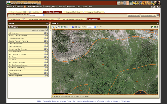
As seen on the image of a study area I selected, under Soil Data Explorer, you will first find an Intro to Soils tab. This opens a list of topics and subtopics surrounding soil use. There is then a Suitabilities and Limitations for Use tab which goes into things such as vegetative productivity, recreational development, agricultural use, and much more. Next is my favorite aspect, the Soil Properties and Qualities tab. It is here that you can discover physical and chemical properties, organic matter content, soil composition, etc. Each of these components gives some type of rating or percentage along with an in-depth explanation of what the ratings themselves signify. During this search, options on how the results are presented can be changed. For example, there is the option to choose whether or not you would like values to be averaged, cut off at a certain point, etc. The entire experience is very customizable based on what you are looking to find out. Lastly, there is a Soil Reports tab which allows users to explore a collection of reports that present soil interpretations related to the topic of their choice. An extremely helpful component of each of these categories is that everything has a “?” button next to the drop down that provides users with a description of what the information in that particular section could be used for.
While the program can be a bit overwhelming at times for new users due to the large quantity of information given, the site is focused on providing people with information in the most organized and systematic way possible. I personally think they do a great job of answering any questions immediately as they would arise about the website itself along with its functions, each individual aspect of soil use, and most importantly- the questions about the soil they came seeking to answer in the first place!
Source:
Nrcs. (n.d.). Retrieved July 12, 2020, from https://websoilsurvey.sc.egov.usda.gov/App/HomePage.htm


Comments
Post a Comment